


WATSON™ MOBILE CAD
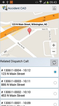
The Watson Mobile CAD module, a public safety mobile CAD software, provides officers with dispatches, maps, status updates, and call information in near real-time. Officers can post status changes and clear calls from their laptop, tablet, or Android Phone. Dispatch locations are viewed using Google Maps™ (including Street View™) and police officers can also use Google Navigation™ if desired when a dispatch is received. The call event detail is also available to populate Incident or Crash reports. For Watson smartphone users, public safety mobile CAD software allows the officer to have CAD functionality without being tied to a vehicle or laptop.
For a list of CAD interfaces please contact us.
Quick Links
Watson RMS Overview Incident Reporting Crash Reporting Ticketing Mobile CAD Evidence Reporting Watson Cloud
